

Latest Weather Blog
Thursday AM Forecast: Much drier today before next round of storms
The Flood Watch for the Capital Region has been cancelled due to continued confidence that the threat of heavy rains has ended this week. While Thursday will be significantly drier than Wednesday, another batch of storms will roll through to kick off the weekend.
Today & Tonight: Mainly clear skies overnight resulted in a cooler start Thursday, with lows near 60 degrees. Plenty of sunshine today will help afternoon highs warm into the 80s. Winds will be light today, and chances of rain are slim. A spotty shower or two may develop during the afternoon, likely along the coast. Overnight, clouds will move back in as Gulf moisture returns, and temperatures will fall into the middle 60s. A few isolated storms may develop around daybreak Friday, especially south of I-10/12.
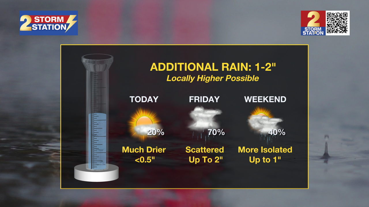
Friday: Numerous showers and storms will be possible throughout the day on Friday. Constant rain is not expected but on-and-off thunderstorms could interrupt outdoor plans at any point tomorrow. When not raining, conditions will be cloudy and mild, in the 70s. Those heading out to Alex Box Stadium tomorrow night should keep rain gear handy and monitor the forecast closely.
Mother's Day Weekend: Isolated showers and storm chances remain over Mother’s Day Weekend, also thanks to a lingering disturbance in the atmosphere. Although the flood threat remains low, stronger storms might contain some hail. Look for cooler mornings in the low-60s and mild afternoons in the upper-70s.
Next Week: A shift in weather pattern by Tuesday of next week brings back largely dry conditions, lots of sunshine, and in return, a warming trend. Highs will likely flirt with the 90 degree mark again by the end of the week.
Trending News
Get the latest 7-day forecast and real-time weather updates HERE.
Watch live news HERE.
River Flooding: The National Weather Service has issued a RIVER FLOOD WARNING for the Mississippi River at Red River Landing, Baton Rouge, and Donaldsonville, the Atchafalaya River at Morgan City, and the Tangipahoa River at Robert. For the latest levels and forecasts, CLICK HERE.
- Emma Kate C.
The Storm Station is here for you, on every platform. Your weather updates can be found on News 2, wbrz.com, and the WBRZ WX App on your Apple or Android device. Follow WBRZ Weather on Facebook and X for even more weather updates while you are on the go.
More News
Desktop News
Click to open Continuous News in a sidebar that updates in real-time.