Heavy downpours continue Wednesday morning, Flood Watch remains through Thursday night
The National Weather Service has issued a FLOOD WATCH for East Baton Rouge, West Baton Rouge, Ascension, Assumption, Iberville, East Feliciana, Livingston, Pointe Coupee, St. Helena, St. James, St. Mary, Tangipahoa, and West Feliciana Parishes as well as, Amite and Wilkinson Counties starting Tuesday evening and lasting through Thursday evening.
A FLOOD WATCH means conditions may develop that lead to flash flooding. Flash flooding is a very dangerous situation. Be on the lookout for threatening weather conditions and listen for later statements and possible warnings. For more on flooding safety, CLICK HERE.

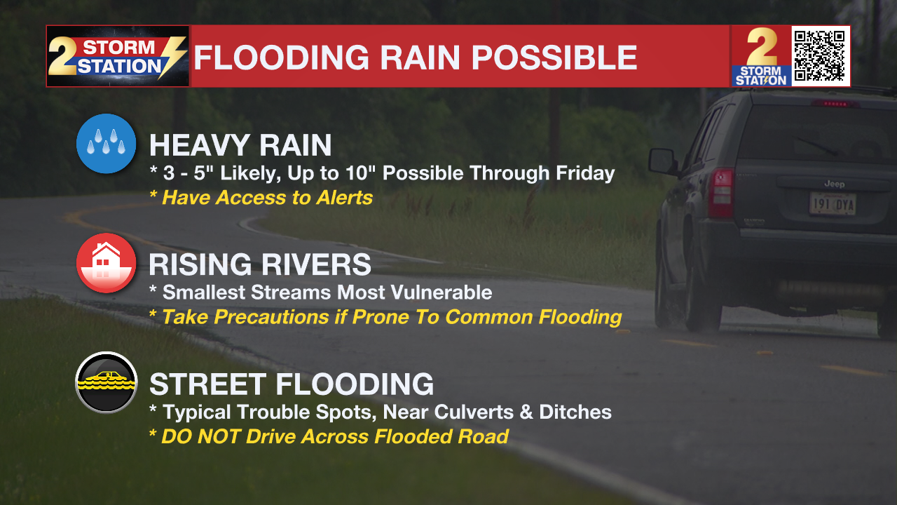
An additional two to four inches of rain are likely though Thursday night across the area, with up to 10" possible in total by the end of the week. Locally higher amounts are possible. Excessive runoff may result in flooding of rivers, creeks, streams, and other low-lying and flood-prone locations. Creeks and streams may rise out of their banks. Flooding may occur in poor drainage and urban areas. Scroll down for additional forecast information.
Remember that the WBRZ WX App. is *free* on Apple and Android devices and can be used for breaking weather information, live radar, and forecast details. You can also use it to watch live coverage if power or broadcast signal is ever lost. For even more, connect with the Storm Station on X and Facebook. Stream WBRZ+ for continuous information as it becomes available.
Click HERE to watch WBRZ streaming live online
Click HERE for the WBRZ weather page.
Click HERE to see how to download the WBRZ weather app.
Wednesday: The highest threat for flash flooding will be before daybreak as showers and storms begin to train over the area. Expect several more inches of rain through daybreak. This could lead to poor drainage flooding, and a lot of ponding water on roadways. Use caution if driving this morning, and remember, turn around, don't drown! Showers and thunderstorms are expected to linger through the morning with a break in the action by afternoon. Mainly cloudy skies will remain as temperatures hover in the upper 70s. Don’t get too comfortable in any dry time—more rain will be on the way. There is some uncertainty as to when the next round of showers and thunderstorms will develop. A weak impulse in the atmosphere could reasonably set off some more activity during the evening or overnight, but it is also plausible that there is not enough energy for storms until the atmosphere recharges and a stronger impulse arrives.
Up Next: Another round of showers and thunderstorms will spark in response to an impulse in the atmosphere pushing a front south across the region late Thursday into Friday. At that point, any extra rain would aggravate the flash flood risk due to previously saturated soils. Friday brings lower coverage in showers and thunderstorms, but still 40% of the 13 Parish, 2 County Area is pegged for measurable rain. New to the forecast, isolated showers and thunderstorms have been added for Saturday and Sunday as well, thanks to some lingering energy into the weekend. Though the flood threat should be lower, some hail may occur in any storms. By early next week, expect some drier times with more sunshine, lower humidity, and comfortable temperatures.
River Flooding: The National Weather Service has issued a RIVER FLOOD WARNING for the Mississippi River at Red River Landing, Baton Rouge, and Donaldsonville, the Atchafalaya River at Morgan City, and the Tangipahoa River at Robert. For the latest levels and forecasts, CLICK HERE.
The Storm Station is here for you, on every platform. Your weather updates can be found on News 2, wbrz.com, and the WBRZ WX App on your Apple or Android device. Follow WBRZ Weather on Facebook and X for even more weather updates while you are on the go.


