

Latest Weather Blog
UPDATE: Rain to become less widespread, Flood Watch removed in some areas
The FLOOD WATCH has been cancelled for Metro Baton Rouge and points northwest, but remains in effect for Ascension, Livingston, Tangipahoa, St. James, Assumption, and St. Mary Parishes until 7 p.m. Thursday.
Although rain will be less widespread in the coming days, scattered downpours will be possible. The potential is there for an additional one to two inches of rain in select areas through Friday. With saturated soils in play, the risk of flash flooding still exists in areas affected by these downpours. In reality, only a few point locations would experience problems through the remainder of the week—and likely for areas east of Baton Rouge. Scroll down for additional forecast information.
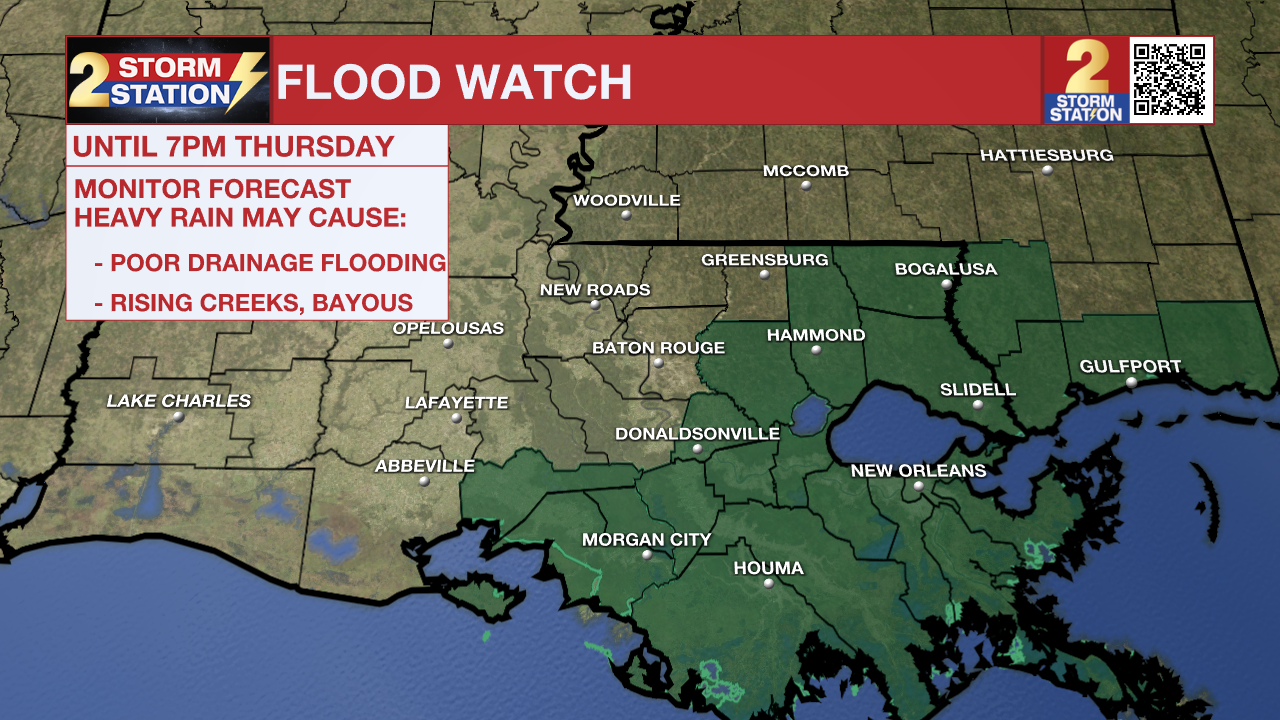
A FLOOD WATCH means conditions may develop that lead to flash flooding. Flash flooding is a dangerous situation. Be on the lookout for threatening weather conditions and listen for later statements and possible warnings. For more on flooding safety, CLICK HERE.
Remember that the WBRZ WX App. is *free* on Apple and Android devices and can be used for breaking weather information, live radar, and forecast details. You can also use it to watch live coverage if power or broadcast signal is ever lost. For even more, connect with the Storm Station on X and Facebook. Stream WBRZ+ for continuous information as it becomes available.
Click HERE to watch WBRZ streaming live online
Click HERE for the WBRZ weather page.
Trending News
Click HERE to see how to download the WBRZ weather app.
Tonight & Tomorrow: After a soaking rain earlier in the day, the atmosphere will be in recharge mode for the time being. A break in rain will also correspond with a period clearing during the evening. With only a few low clouds developing overnight, temperatures will manage to dip into the lower 60s. A few areas of fog will be possible by sunrise. A stray shower or two also cannot be ruled out, but the overall nighttime stretch will be significantly drier. The atmosphere will remain somewhat worked over into Thursday, allowing more sun to shine. That will push highs into the middle 80s once again. The afternoon warmth could pop some isolated storms, but there will be lots of dry time.
Up Next: Another round of isolated storms appears to develop late Thursday in response to an arriving impulse pushing a front into the region. During this time, any extra rain could aggravate the flash flood risk due to previously saturated soils. Nevertheless, it would only be an issue on smaller scales—not a widespread issue. As the atmosphere will have had time to recharge, numerous showers and storms will be possible on Friday. Isolated showers and storms remain over Mother’s Day Weekend also thanks to a lingering disturbance. Although the flood threat would be lower by then, stronger storms might contain some hail. By early next week, expect drier times with a boost in sunshine and comfortable temperatures.
River Flooding: The National Weather Service has issued a RIVER FLOOD WARNING for the Mississippi River at Red River Landing, Baton Rouge, and Donaldsonville, the Atchafalaya River at Morgan City, and the Tangipahoa River at Robert. For the latest levels and forecasts, CLICK HERE.
The Storm Station is here for you, on every platform. Your weather updates can be found on News 2, wbrz.com, and the WBRZ WX App on your Apple or Android device. Follow WBRZ Weather on Facebook and X for even more weather updates while you are on the go.
More News
Desktop News
Click to open Continuous News in a sidebar that updates in real-time.
News Video
-
Woman arrested for alleged connection to Amite shooting that left two teens...
-
St. Mary Parish buildings damaged, roads flooded after Tuesday's heavy rainfall, strong...
-
Most travelers must have a REAL ID now to fly in US,...
-
Man arrested after argument at Baker crawfish boil led to fatal shooting
-
Expert explains as papal conclave begins Wednesday in Vatican City